Ever since seeing the sign leading down from Penzance Harbour to the Scillonian III check-in point last year, I've wanted to visit the Scilly Isles (which I'm told should only ever be referred to as the Isles of Scilly...)
It is possible to do this as a day trip; either by helicopter, plane or boat, or a combination of plane and boat. We took the cheapest option (£12.50 each way on the boat in October). Yes, the journey does take 2hrs 45mins, so that's a lot of travelling for only 3½ hours in the Scillies, but I was told that the journey itself is part of the experience- and so it was!
The Scillonian III has been in service since 1977, the third of a series of passenger ferries to St. Mary's- the largest island in the archipelago. The service began in 1926, the Scillonian II first sailed in 1956 and the Scillonian IV has already been commissioned.
I've also created a YouTube vlog about St Mary's, link here:-
Here's a PDF of the Scilly Isles.
They consist of around 140 islands (55 visible at high tide) although only five are occupied. They are: St Mary's, Tresco, Bryher, St Martin's and St Agnes. Gugh is joined to St Agnes by a tombolo, which is an isthmus, or a kind of sandbar. It is called the Gugh Bar and is exposed only at low tide.

They lie 28 miles (45km) off Land's End, as this PDF shows, although some guides stipulate 25 miles (40 km).
Written evidence exists which suggests that it's likely that the individual islands were all once larger, and perhaps joined to form one island named Ennor, until 400-500 AD, when rising sea levels flooded the central plain...

Here are my tickets, photographed on top of a sparkly shrug I bought in Penzance...

Leaving rainy Penzance Harbour, and I decided to travel starboard out (those of you in the know will know that doesn't make me posh...😉) on the upper deck as I wanted to take in the coastal sights. Alas, it wasn't possible to make out much detail, what with the weather being as squally as it was.

The coast, and despite the choppy sea the water still looked a lovely jewel green colour...

Or should that be kingfisher? Or steel blue? Or dark duck egg? (You can tell I once worked as a fashion designer can't you?!😄)

The ride was quite rough. The boat has to have a flat bottom, so that it can enter the harbour at St Mary's. As a result, it tends to rock forwards and backwards as well as from side to side.
The ferry is known as the Great White Stomach Pump or, alternatively, the Vomit Comet, as it's notorious for seasickness.

You can see the waves crashing up against the coast here.
Was I ill? Hell, no! I did feel a bit queasy at one point, but the dodgy part appeared to be my lower, rather than my upper stomach, so a good "sit down" sorted me out. Is that too much information? If it is, tough. You know bawdy little moi will never miss the chance to pontificate about anything lavatorial and relevant to British postcard humour; such as bums, tits, willies, fornication and bowel movements....😜

Three hours later, and it was raining as we entered St Mary's Harbour, but that didn't in any way diminish its aesthetic appeal.
St Mary's is the largest island in the archipelago and the most inhabited, containing 1,800 residents out of the total Scillonian population of around 2,200.

We took a short, wet wander. Peering out between the buildings onto St Mary's Pool and trying to get my bearings, the land over the way is the main body of St Mary's...

We decided to reverse the short way back to the harbour, to escape the wet weather and get some food in the Mermaid Inn. This cosy pub also has the Mermaid Restaurant upstairs and the Slip Inn to one side.
We sat here and drank extra strong coffee, and I ate a delicious crab sandwich with fries (which was actually my breakfast...) I'd certainly visit here again.

We took a wander through Hugh Town. This little chunk of the island was the only part we concentrated on. We didn't have the time to take in much else, and island hopping on such a short trip was out of the question. There were only a limited amount of inter-island ferries running anyway.

The Bishop and Wolf pub and the Hugh Street Cafe. This area was made up of small craft and traditional shops, such as a delicatessen and a butcher's, along with a Co-op supermarket...

Venturing onto Porthcressa Beach, past the toilets and picnic area. The long white chimney in the background belongs to the island's power station. I sat at the table, and I had to sit on a plastic bag as it was still wet...

Seagulls like to claim their space around here. Luckily we weren't eating, or we'd never have been left alone!

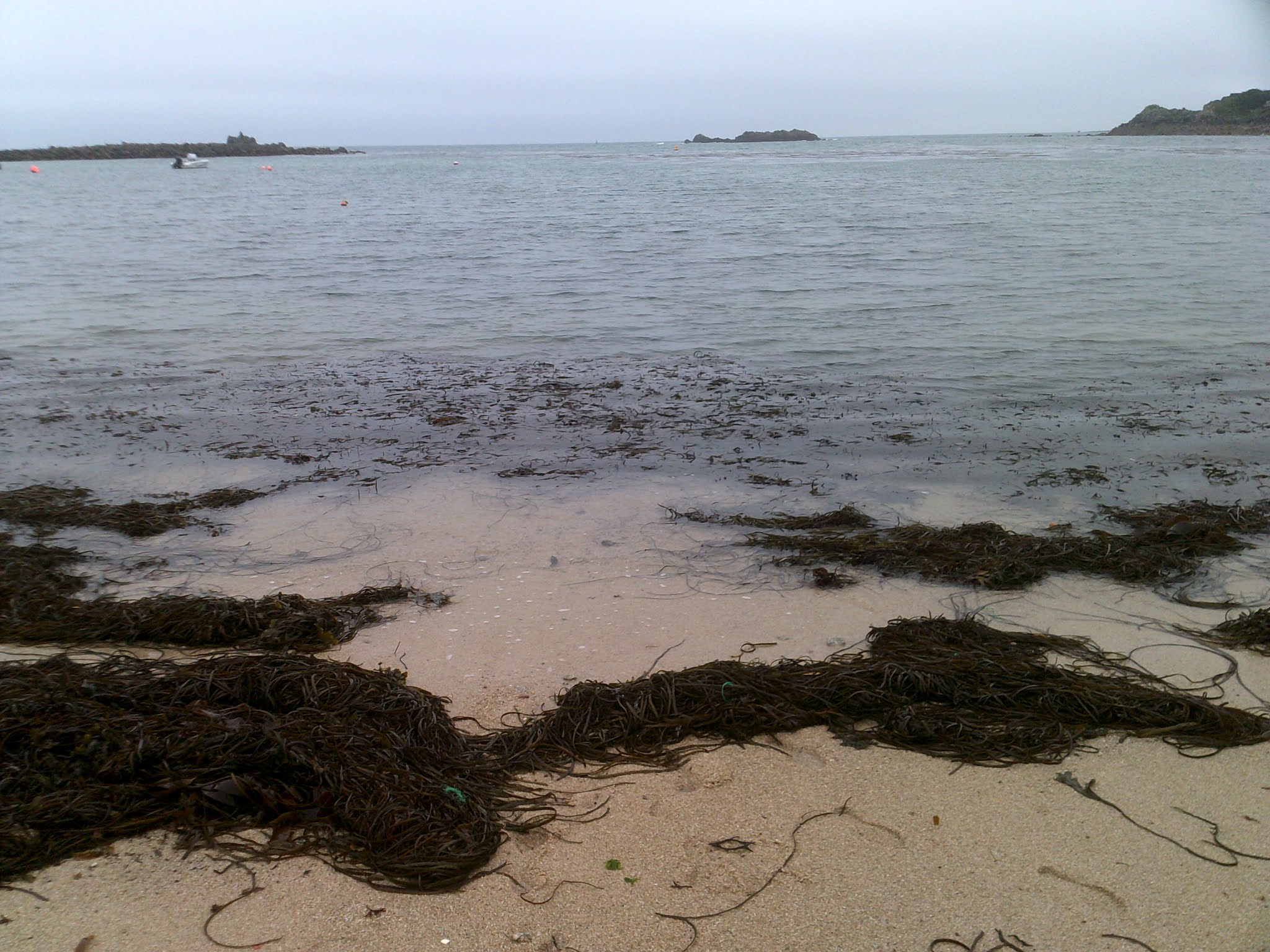
This beach looked rather cute, with a mixture of boulder rocks at the side, thick yellow sand and lines of seaweed...

Stepping onto the beach and looking left...

Further back left, and it looks like it consists mostly of hilltop fields dropping down towards the sea...

View right...

View further back right, to houses and civilisation. In all my time I've never met another person who's been to the Scilly Isles. Apart, that is, from a guy I knew in Norfolk, who was born and raised here. He was a diving instructor, if my memory serves me correctly, and this location lends itself well to water sports.

I dipped my foot into the water and it felt warm (like the rain!) for October.
We took a walk back through Hugh Town. The Old Wesleyan Chapel building dates back to 1828, was refurbished in 1884 and 1905, but became disused as a place of worship during the 1930s. It now functions as an office of the Council of the Isles of Scilly, and you can get married here if you so wish.

I loved this duck ornament, high up in someone's garden! The Duchy of Cornwall, which funds the activities of the Prince of Wales (currently our Prince Charles) owns most of the freehold land on the islands.

We climbed upwards, leaving the coast behind. The Scilly Isles are often referred to as the sunshine isles, as they enjoy more hours of sunshine than any other part of the United Kingdom.

The Garrison Gate.
The islands' defences were neglected until the probability that Philip of Spain would send a second armada was considered. The Hugh, a prominent part of jutting headland was chosen as the site for the garrison, which consisted of a coast-to-coast wall, four bastions, a fortified entrance and Star Castle at its core.

To the right of the picture is the Rocket House, a sunken powder magazine. It's a 17th century structure with a massive blast wall as, at this time, accidents with explosives were not uncommon. To the left is the Detention Cell.
The Garrison Walls are run by English Heritage, but the visitors' history exhibition was closed on this day.

The Detention Cell...

View inside, and it's very poky, as you'd probably expect...

Looking to the side and the weather was starting to dry up (how British, waxing lyrical about the weather yet again...😁)

Looking back out of the Garrison. Large numbers of servicemen were stationed here during the First and Second World Wars.

The walk up to Star Castle, which was once the fortress of the Garrison. The wall was extended during the 17th and early 18th centuries, until it surrounded most of the headland.

Many of the surviving buildings date from this time. It was then that The Hugh became known as the Garrison. The Union Jack flies in the distance proudly atop its pole.

Star Castle is built in the shape of an eight-pointed star, and is now a hotel (tourism now forms 85% of the islands' income.) It was originally constructed in 1593, under the direction of Francis Godolphin, Captain of the Scilly Isles.

One of the eight points of the star is prominent to the right of the photo. The star features on the flag of the Council of the Isles of Scilly.

The day was brightening up as we looked back over the harbour we'd arrived at.
To the left of the photo is Telegraph Tower, a communications tower that looks like a skinny electricity pylon. It is in a settlement of St Mary's that takes its name from the tower, and is known as Telegraph.

Homes stuck onto the side of the sloping cliffs...

18th century Newman House is a self-catering holiday home, and is available to rent. Tresco, Bryher and uninhabited Samson can be seen over the water.

Looking back down over St Mary's Harbour, with the Scillonian III in the harbour and St Martin's in the far distance...

Tresco and Bryher are the land masses juxtaposed against the clearing sky. The clifftop bracken was a deep, rusty red.

We trudged round the headland, and I really love that palm trees feature prominently here; a sign of the temperate climate.

Woodland lane beside an area set aside for camping...

Navigating the muddy path to Woolpack Point Battery...

St Agnes is across the water...

Overlooking St Agnes, and St Agnes Lighthouse. Its isthmus, Gugh, would be the lump to the left...

Walking back into town, fully appreciating our pretty positioning in the midst of the archipelago...

The harbour arm once again, with St Mary's Pool behind it.

Retracing our steps down into Hugh Town, a bit closer to the coast this time...

The Kavorna Café & Take Away, with the Post Office further down the road behind it. When we first passed it the café seemed very popular, with a queue (no doubt consisting of passengers from our boat) forming.

Holgates Green is simply known as The Park...

It's a calm green space, and here's the view from the other end...

The war memorial in this park is known as the New Memorial, as it was only erected in 2014, as the original in Old Town was considered too far for veterans to walk to.

The SuperDean had a twiddle with this pump, and the handle does work...

...Although no water was forthcoming! He reminds me of a big schoolboy, in his shorts and peaked cap!😀

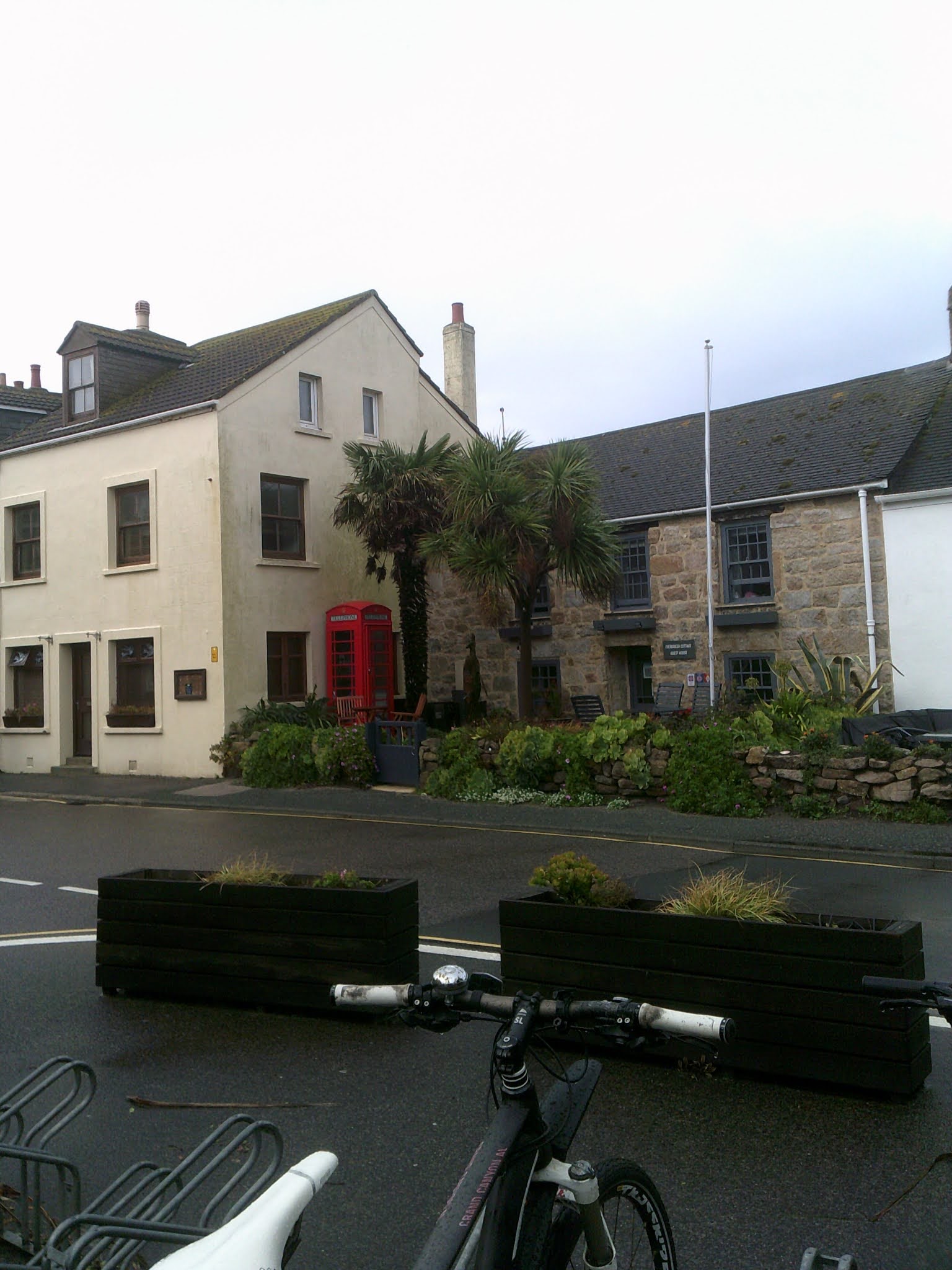
Wow! A red phone box- you don't see many of these nowadays, which is a real shame.
I do understand that there's less call for them, as most of us own cell phones, but I hope they don't disappear completely.
Looking over the garden fences, as we took in a side view of this street surrounding the green, on the walk back to the beach.

We wanted to know why this garden was attracting a small audience, and here's a close-up. It is cute, but the main draw was the melody of birds (although I don't see any here!) twittering...

The clearing sky at Porthcressa Beach. The rain had long stopped and it was quite clement for October...

My last photo of Porthcressa beach was taken using my phone. Although I'm not a fan of using phones to take photos (I don't like them as a piece of photographic equipment; I have an inclination towards a proper camera I can adjust the settings to, and carry on a wrist strap) I prefer this photo to the one above.
The sky was clearing and the ambience blissful.💙

Samson, Bryher and Tresco in clear view, as we made our way back to our boat...

The beach is a mixture of harsh, rugged rocks, and glorious, thick yellow sand.
The white needle far, far away in the distance (roughly centre of the photo) is Round Island Lighthouse. It sits on an island of its own, north of Tresco and St Martin's.

Looking over the beach and harbour, with the Scillonian III in the dock...

Corner view of the Mermaid Inn, with the door to the Slip Inn under the smaller signpost.

Closer view, and I like the mermaid sign. I've seen older photographs, where it had a more detailed painting of a mermaid showing off her breasts!

Venturing back towards the Scillonian III, after only 3½ hours on the island...

Goodbye (for now) St Mary's...

I took the lower deck home, facing port so I could get some pictures.

Our timing here was pretty good, as it started to tip down again...

...But look at the fantastic colourings as the weather cleared and we made our way out onto open sea. The sea was smoother on the journey back to Penzance than it had been on the way out. I was told that this is normal, and something to do with the meeting and swell of tides as you leave the corner of England.

The small spike to the left of the photo is Longships Lighthouse, which is 1.25 miles (2 km) off the coast of Land's End. The coast you can see here is actually part of the knuckle of land that becomes Land's End slightly further back. It wasn't easy to capture in this gathering dusk! The lighthouse dates back to 1795 and was automated in 1988. It's 39 feet (12 m) above sea level and is definitely working.
It actually gave me a thrill, seeing land for the first time since leaving the Scilly Isles, and spotting the flashing light, which was so far away it looked like a matchstick! (Little things please little minds 'n' all that....😄)

Dusk was falling but the water still a beautiful, clear, darkening lapis lazuli blue as we passed the Minack Theatre and Porthcurno Beach. The theatre looks like it's been carved into the cliff face, and stages open-air plays from Easter until September...

Here is the photo blown up- as you can see, it's not giving too much away! The theatre is picked out by the lights going down into the sea. The view (when you can see it) is said to be spectacular.

We docked at Penzance Harbour and made our way to the pub for a snack and a drinkie.
Could I live in the Scilly Isles? I gave it a long thought and no, probably not. It's a bit too isolated even for introverted moi, and links to the land are tenuous during the winter months (the Scillonian III doesn't run then, although the aeroplanes do.)
But I will definitely return, and next time I want to stay for a few days and island hop....
Until then, TTFN,
The Miss Elaineous
XXXXX
XXX
X
No comments:
Post a Comment