St Mary's was our base when we stayed in the Isles of Scilly, and it's the largest of the five inhabited islands.
We had visited before, in 2020, but only for a day trip- read about that here:-
I've also created a YouTube video about the island, link here:-
Here's a PDF of the archipelago.
Of the 140 islands, only 55 are visible at high tide. Five are occupied, and they are: St Mary's, Tresco, Bryher, St Martin's and St Agnes. Gugh is joined to St Agnes by a tombolo, which is an isthmus, or a kind of sandbar exposed only at low tide.

Leaving Penzance on the Scillonian III ferry service, and the islands lie 28 miles (45km) off Land's End.
.JPG)
Land's End, with Longships Lighthouse the spike visible to the left. It sits 1.25 miles (2 km) off the coast.


This petrol station, launderette and shop was right near us, and I thought it had a real 1970s feel!


Here's the view looking the other way, towards Penninis Head.
Written evidence exists which suggests that it's likely that the individual islands were all once larger, and perhaps joined to form one island named Ennor, until 400-500 AD, when rising sea levels flooded the central plain.

I believe the peninsula to the left of the beach houses open-air Minack Theatre, which is built into the cliffs. It's actually not that easy to spot from the water.
.JPG)

Most visitors to the islands stay in holiday lets, and we were no exception. Here's the outside sign of our charmingly-named apartment on Buzza Street, Hugh Town. I found the name quite ironic, as all summer I'd had masonry bees trying to nest in my own wall!


Porthcressa Beach was only minutes away from us, and here's the view looking towards the Garrison.

I did have a swim in this bay one day, and whilst it wasn't warm it was certainly bearable considering it was October.


This pretty little stained glass hut was built to commemorate either the ascension or coronation (silly me didn't make a note) of Queen Elizabeth II, which makes it 70 years old. She died only a few weeks before we visited.

Looking to the left across Town Beach, and just out of shot lies Rat Island and The Quay. Rat Island was joined to The Quay by the harbour wall- visible to the right- between 1835-38 and extended in 1889.

The next day saw me take a morning walk along a different beach in Old Town Bay.

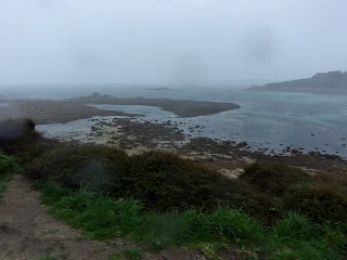
Full bay view, and this was the only day we had where the weather wasn't pleasant, and was already looking very overcast...

The geography of Scilly's beaches did look very volcanic- even lunar!

You can spot St Mary's Old Church,; an Anglican Church which is believed to date from 1130, although re-building occurred between 1660-6, with further improvements happening in in 1743.

.JPG)


Staring out to the sea to the left of the beach...
Looking the other way down from the hill, with Town Beach, The Quay and Rat Island below, with the Scillonian III in dock.

Buzza Tower was first built in 1821, and used as a windmill. The seating was added in 1912, when the tower was restored as a memorial to Edward VII.

We took an early evening walk out to Town Beach, which is only five minutes walk from Porthcressa Beach...

The RNLI Lifeboat Station sits in the centre of the photo, its landing deck sloping down into the sea...


A closer view, and Labour Prime Minister Harold Wilson (1916-95) had a home on the island and is buried in this churchyard, which still serves as the principal cemetery for islanders.
.JPG)
This photo of the church was taken later that day, and we had to careful not to intrude as a wedding was going on. Apparently, the church does not even have electricity, but it does look like a suitably attractive and quaint venue in which to get married.

The day was spitting grottiness by then, but the horses didn't seem to care!

St Mary's Church was consecrated in 1838; replacing the old town church as it was considered inconvenient for the population, and in need of repair.

I took this photo of St Mary's Hall Hotel just because I liked the warm and cosy look of it; shrouded and hugged by the kind of tropical plants which flourish here.

Our Lady Star of the Sea is the island's Catholic Church. The Isles of Scilly's most predominant faith is actually Methodism.

A random lion on a building wall near our apartment... I took this photo just because I'm a Leo...😀

Walking up to the Buzza Tower; looking down on Porthcressa Beach.


Here's the SuperDean having a nosey around and getting a bit of shelter. You can see how wet the day now was by the raindrops infesting my camera lens.


Power station chimney...

Old Town Bay was visible as we made our rustic way towards the lighthouse...

Peninnis Lighthouse was powered by oil gas and first lit in 1911, then converted to automatic acetylene operation in 1922. It stands 14m (45 ft) tall.


Once a disused quarry, it is now a beautiful sub-tropical garden...


A small group were busy undertaking their yoga moves just behind this tree and mini-pond...

The gardens were set up in 1986, with donations of plants and shrubs sent from Tresco's Abbey Garden...


Anyone is welcome to tend the garden, and it's a space everyone can enjoy.

This was my favourite little alcove, and had something of a fairytale element about it...


This is Porthmellon Beach, and it looked the most rugged of the beaches I saw...


It's easy to see how he got his name, and he is one of many strange formations on the islands...

Apparently some dim tourists think he is man made, and ask how long it took to make him- 'Oh, about six million years,' is the answer to that question!

Nowadays, it is used as a camera obscura (to study eclipses without damaging the eye). It has been open to the public since 2014, but there was no sign whatsoever of life inside on this day.

This is the remains of Peninnis Mill. I initially thought this might be a burial chamber as there are over eighty entrance graves recorded on the islands, and most date from the late Neolithic period to the middle Bronze Age (c.2500-1000 BC). The size of the graves reflected the social standing of the person buried within. Multiple interments did take place within a single site, however.


Rat Island and the new harbour arm...

On a more clement day we walked to Carreg Dhu garden, which is more to the centre of the island and is cared for by community volunteers.
I like the way the glare from the sun "kissed" this photo...💛💙💜💚


A closer view of the tree, and SuperDean HAD to get his fat swede into the shot...


It is considered to be small and understated, compared to the aforementioned Abbey Garden, but I believe that's where its charm lies...

Carreg Dhu means Black Rocks in Kernewek, the ancient Cornish language.
I loved the starkness of this evergreen with the sun peeping through; throwing it into silhouette...


Belladonna lilies, fuchsias, daffodils, geraniums and camellias are listed as living here, but these flowers look like hydrangeas...


The next three photos come as an addition to the blog after my third visit to the islands, in 2023.
We walked across farmland and beside hides to Porth Hellick Beach (as rugged as the previously mentioned beach, but in a different, rockier way) on the eastern side of St. Mary's. Our mission was to check out this chap, known as Loaded Camel Rock.


😆


Porthcressa Beach, and overlooking the Atlantic Ocean on the way to dinner.

This view is taken from the Old Quay; a small arm which reaches out to the side of the quay.

💙
.jpg)

.jpg)
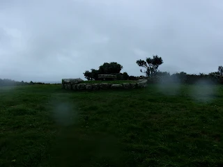
This semi-derelict hut was up near Woolpack Point Battery. Interestingly, a couple of days later the gate was padlocked shut...

We were shooed out by someone the second time we came up here. As it's heritage land, could the Woolpack Point Battery have squatters?

Accessing the Garrison for the second time, via a new way which led off a street...

...Through a Lilliputian doorway, with the 6'2" SuperDean offering up a height comparison...

Having to duck through the access tunnel...

...And arriving up a set of stairs into Sally Port.

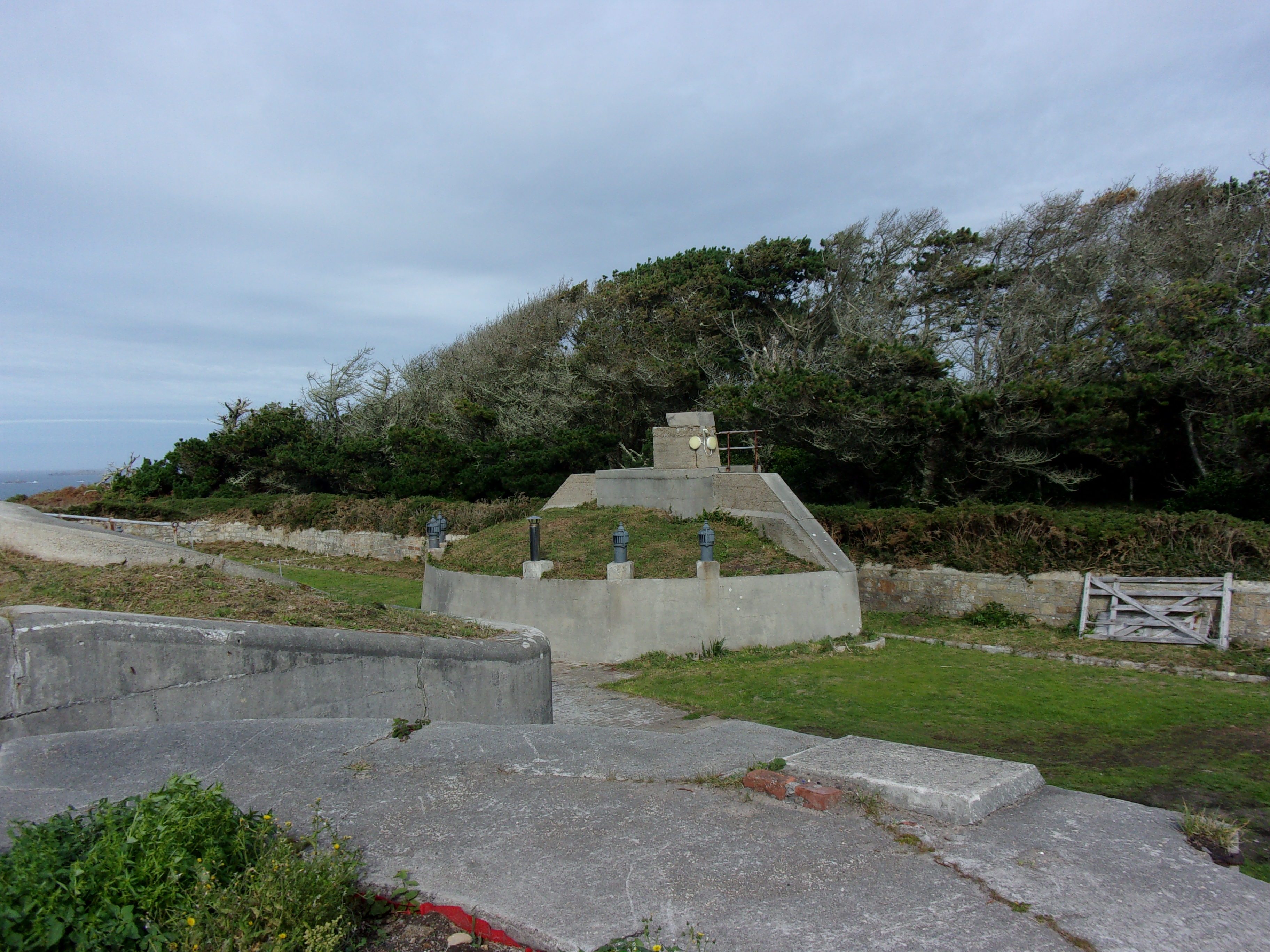
The Garrison fortifications date back to 1593, following the Spanish Armada, with additions throughout subsequent centuries as other threats emerged...

The cannon on display date from the 18th and early 19th centuries...

Town Beach to the left, Porthcressa Beach to the right...

The site is managed by English heritage, and nowadays visitors can walk much the length of the Garrison Walls, which are very well-preserved.

This looks like a sentry box...

A closer view of the gate, and the nucleus of the Garrison was always Star Castle, now a hotel...

I like the way tropical flowers have taken a hold in this nook...

Overlooking Porthcressa Beach and I will spend more time walking the Garrison Walls the next time I visit.

The island is home to many species which survive purely because this is a subtropical environment. This tree had a Japanese feel to it...

Uninhabited Samson is the camel-hump island in the centre of the picture. You can take tours to it, and I might have to give that a go next time I'm here...

The Isles of Scilly Museum shows a wide range of artefacts and a rich history of wrecks.
This cabinet was about Harold Wilson, and included his telephone, which was kept at the Custom and Excise house, and allowed him to have direct contact with No.10 Downing Street during his holidays.

A cabinet commemorating the Isles of Scilly visits of our dear Queen, who'd passed away only weeks beforehand.

The Pilot's Gig was a restaurant and bar. Here is a plaque of a traditional Scillonian Gig (a six rower craft once used as a general work boat) which sat above their bar.
.jpg)
Stained glass window, and gig racing is still a regular Scillonian sport...
.jpg)
Stained glass puffins, and the Pilot's Gig do FANTASTIC pizzas...
.jpg)
Stained glass window representing a gig...
.jpg)
Olde-worlde range...
.jpg)
In the Atlantic Inn, I read Coddswallop (sic) corner as "Oddswallow Corner!"
I would...😉

I did like Bullshit Corner, in the Mermaid Inn...😁
There must be something about this corner, as the first time we came to this pub, during our day trip, this seat was occupied by a moaning old cow. Then, when she left, a party containing a whinging man took her place.
We tried our best to break the chain and be happy when we sat here!😁
.jpg)
The Scillonian III could not sail on the day we were to leave, due to gale force winds, so we had to consult with Tourist Information and managed to get a lovely, friendly B&B called Nancherrow for the night.
Here's the rainbow that tried to peek out later in the day, with this view overlooking the airport on the horizon.

Harold Wilson's home was right near our B&B. It is considered the most boring house on the island!

We sat on the upper deck for a while as the boat left the islands. You can make out the Daymark of St Martin's at the end of the land, if you peer...

The setting sun, once we were in sight of the mainland...

We also had to face a train strike and a limited service the next day, so once we'd settled back in Penzance we headed out for a shot or two...😉

This was my little present to self- two pretty bracelets in an organza bag, from a souvenir shop called Tideline on St Mary's.

Isles of Scilly, I am booked to return next autumn, and there's plenty more I need to see and document.
Until then...
TTFN
The Miss Elaineous
XXXXX
XXX
X
XXX
X
No comments:
Post a Comment